


Optimize Your Fall Sulfur Application with SWAT MAPS
Thursday, August 22, 2024 3:27 PM
Reading Time: 2 minutes
Jessenta Woloshyn
Senior Precision Agronomist
jessenta.woloshyn@swatmaps.com
Applying sulfur in the fall has become a common practice in parts of the world. Discussions about timing, temperature and moisture occur every year when producers are making decisions about their fall applications of sulfur. When using an ammonium form of sulfur, such as sulfur fines, applying it in the late fall helps to avoid loss of this readily available form of sulfur. By contrast, when using an elemental sulfur, applying it earlier in the fall allows for oxidization, an important step in the process. Understanding how either form of sulfur product can be applied is necessary to get the best return on the investment in sulfur, and the most beneficial use of SWAT MAPS.

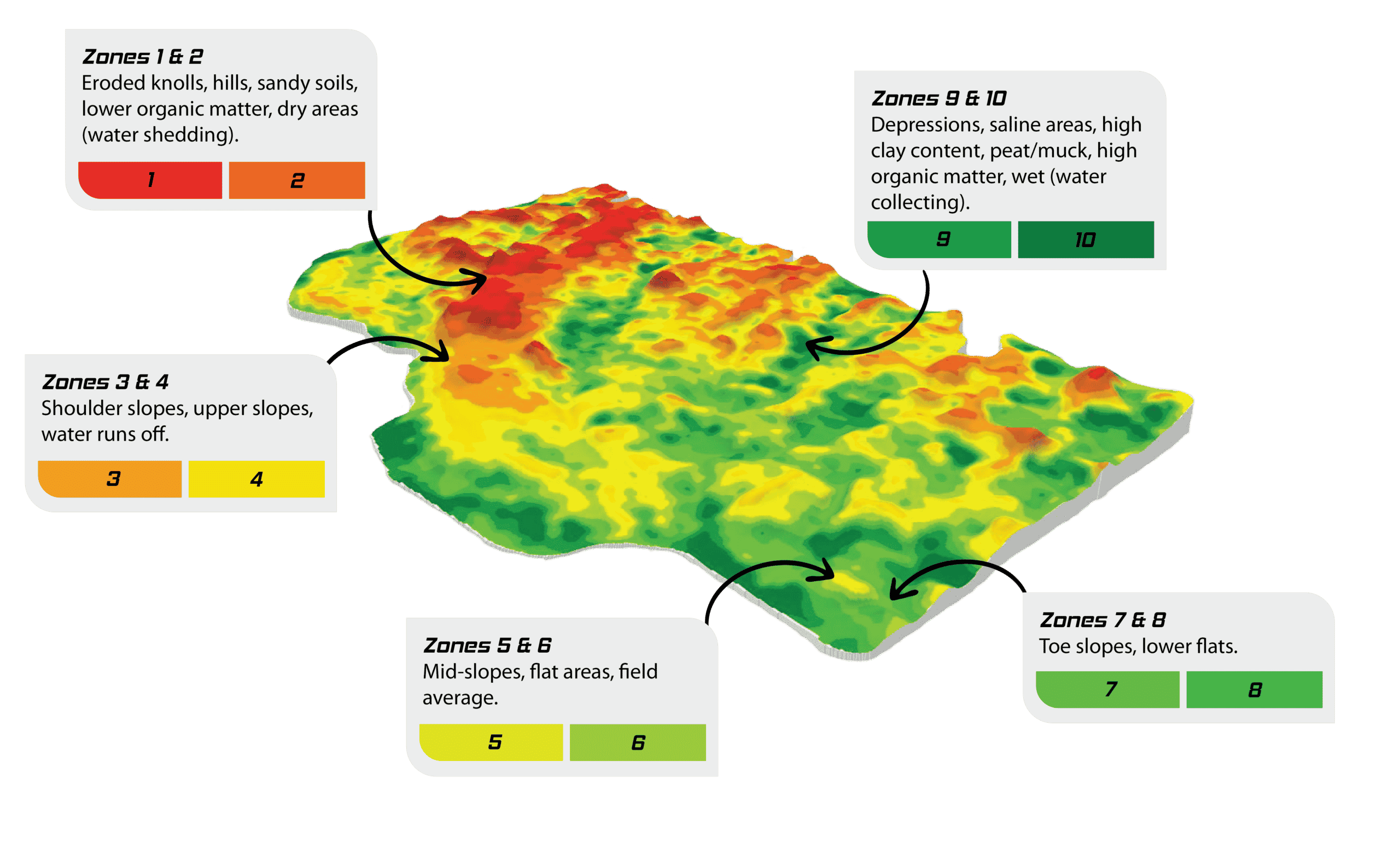
SWAT MAPS breaks fields into 10 zones, to understand different soil types, topography and nutrient variability of each field. Sulfur could be considered one of the most variable nutrients, and SWAT MAPS can help us understand the trend of sulfur within each field. This information allows us to dig deeper into sulfur requirements and use a 4R (right rate, right time, right source, and right place) approach for sulfur application rates.
SWAT MAP’s zones 1 and 2, shown in Figure 1, tend to be lower organic matter or sandy areas of a field, often being the “upper landscapes” within the field. Hydrology within a field has many affects on sulfur because water causes movement of sulfur, as does soil erosion. Both factors cause sulfur to move from upper landscape positions to water-collecting areas of the field. When using variable rate with SWAT MAPS, we are able identify areas where sulfur has moved from upper landscape positions and apply sufficient amounts of sulfur in these areas to ensure sulfur is not a limiting factor for the crop there.
Zones 9 and 10, being water collecting areas, high electric conductivity areas and higher organic matter areas, will often not require much sulfur, if any. Between water bringing sulfur to these areas or sulfate-salts being present when saline, there is often a large amount of available sulfur already present in these zones. With the increase in organic matter percentages, we can account for more sulfur contributed through mineralization during the growing season in these areas as well. The use of SWAT MAPS gives us the ability to understand where these areas are within the field. The amount of sulfur contributed by mineralization has been largely underestimated with approximately 1 pound of sulfur for every 10 pounds of nitrogen available through mineralization.
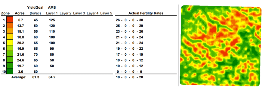
Figure 2 shows an example of a variable rate sulfur application, displaying the trend of sulfur required in this field. When SWAT MAPS is used for fall sulfur applications, sulfur is reallocated to the areas of the field that are more responsive and will have a stronger return on investment. Historically the field in Figure 2. would receive a flat rate of 100 lbs/ac of ammonium sulphate. With the use of SWAT MAPS we can reduce rates by 15% and still apply higher rates in parts of the field where it is needed.
Want to discuss more about your fall sulfur application? Get in touch with your SWAT MAPS agronomist, we’re happy to chat!
Become a SWAT News insider!
Sign Me Up!
Join Our Mailing List
Enter your email below to sign up for our mailing list.
We care about the protection of your data. We’ll never share your details.

Croptimistic Technology Inc. is an international agriculture technology (AgTech) company. We began operating in 2018. Croptimistic is supported by a growing team of professionals who have dedicated their careers to developing the best soil mapping software and hardware in the world.
Copyright Croptimistic Technology Inc. © 2025 All Rights Reserved.
Privacy Policy