


Understanding Site-Specific Field Variability and Modifying SWAT MAPS
Tuesday, July 25, 2023 1:53 PM
Reading Time: 4 minutes
Kerrie de Gooijer, PAg, CCA
Senior Precision Agronomist
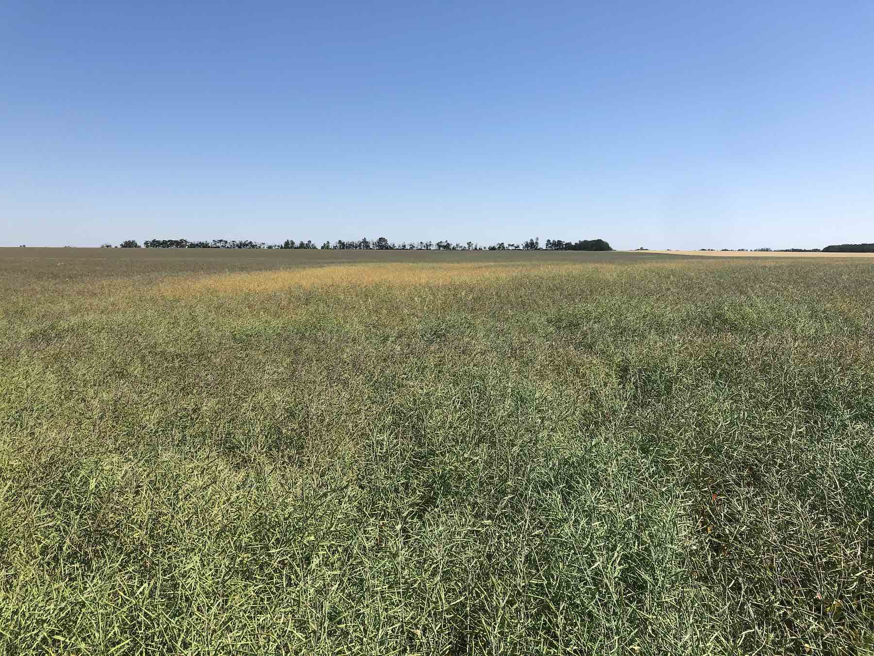
One of the best times to assess fertility and moisture-based variability within fields is as the crop is coming into maturity. This is when moisture stress and nutrient deficiencies have the potential to show up. It is when lodging and delayed maturity issues in areas of the field are more pronounced. A late-season crop assessment is beneficial for identifying problem areas and creating a management plan to address these concerns. Managing your crop using SWAT MAPS can help even out crop maturity. If you are already a SWAT MAPS customer, it is also a great time to validate the chosen SWAT MAP.
After a field has been mapped, an agronomist ground-truths the field and selects the map option that best represents what they are seeing at the time of soil sampling. The highest and driest areas of the field should be grouped together as a zone 1. The wettest, most saline (if you have salinity) areas of the field should be a zone 10. There are times, however, that the map can be modified as we learn additional information about the field. This is one benefit to having agronomists and growers actively assessing crops and fields during the growing season, and seeing how everything aligns with the map.
General field variability
Many factors can cause variability in a field. We are interested in capturing soil, water and topography attributes with our maps. These are stable properties and no matter how flat the field, water always goes somewhere. The texture differences across the field will always be variable.
Field variability in dry years
A particularly dry year can accentuate variability in your field. For example, a subsoil gravel seam may not be noticeable in a wet year but in a dry year, crop growing on that seam burns up early in the season. Light or moderate salinity may not be noticeable if a field has been getting ample moisture, but really shows up when rain is limiting.
Checking crops during pre-harvest staging and making note of these variability factors can help us better manage these areas in the future. A SWAT MAPS agronomist or service provider will ground-truth the SWAT MAP and see if the variability is matching up with the map or the electrical conductivity (EC) layer.
Example modifications to a SWAT MAP
At Croptimistic, we don’t claim to be perfect but are always striving to do better. SWAT MAPS are a solid tool for land management and can always be improved upon. We often make improvements to pre-existing maps. Our agronomists visit the fields during the growing season to do general agronomic assessments. Every year has the potential to be different, but the main goal of these assessments is to evaluate if the strategies we employed in the spring are working. Is the crop more even? Is there opportunity for additional modifications and changes to upcoming fertilizer strategies? Are certain areas of the crop burning up, and is there opportunity to modify our fertilizer strategy to reduce risk in these areas? Are these areas lacking fertility? There are a multitude of potential questions to be answered.
Occasionally, we come across a situation where the agronomist may feel it is necessary to modify the SWAT MAP we chose during the soil sampling stage in the first year. A common modification to a map involves creating a “mod area” where a known past management practice changed only a small area of the map. For example, bush/trees, corrals, or old yards were removed, or old septic fields are no longer in use. These areas won’t necessarily be picked up in the final map or in “normal years,” but past management practices resulted in these areas mineralizing more than the rest of the field. We can add a mod area so we can better manage the specific area with our fertilizer recommendations.
Another modification can include changing the SWAT zones to better align with persistent environmental factors, which may include underlying subsoil features that change only in particular zones.
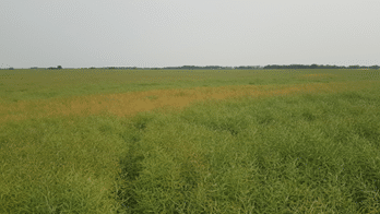
Case study: modifying a SWAT MAP due to isolated soil texture differences
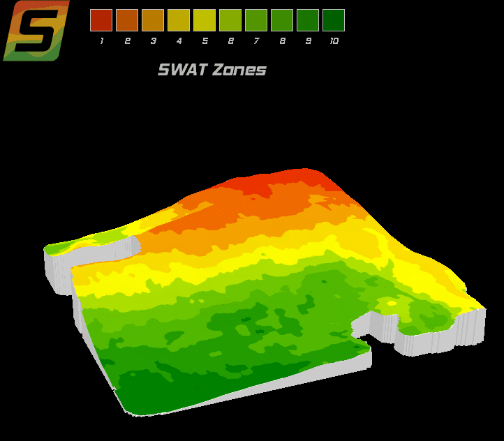
During a pre-harvest VR assessment in 2021, it was noted that there was an area of a field maturing significantly earlier than the rest. This area in question was not located in the typical driest zone 1 highest topography area of the field, but was more closely aligned with the lower EC area. This scenario provided us with the opportunity to modify the SWAT MAP to delineate and isolate the coarse-textured soil in this field, which was verified through review of past NDVI imagery.
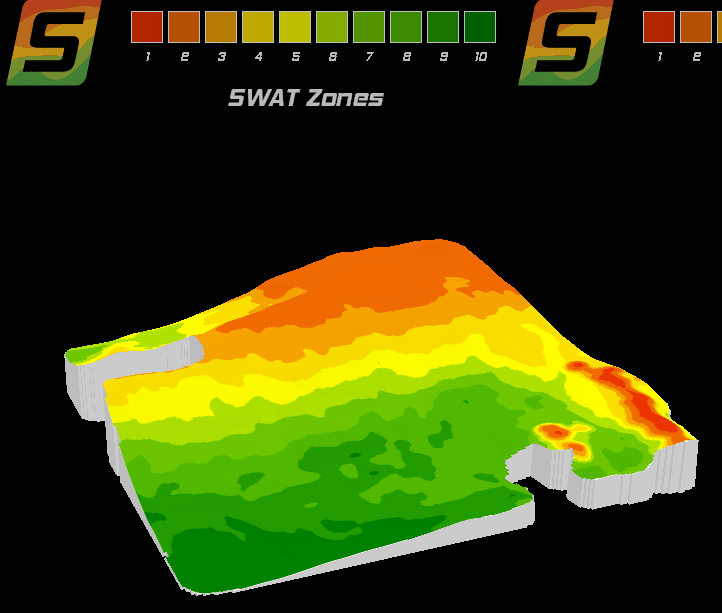
The top of the hill on the most northern part of the picture is now a zone 2. The new zone 2 area is up on a hill and is still classified as drier but has greater moisture-holding capacity than the new zone 1 area. These areas can be now managed differently because of the edited SWAT MAP.
Managing field variability using SWAT MAPS
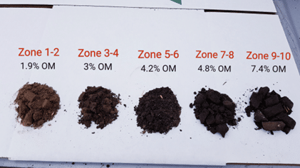
Soil testing by zone is an important tool to manage fertilizer requirements after a drought year. If crop yield was poor on the hilltops and sidehills, it is likely there will be higher residual nitrogen levels in those areas. In contrast, normally high producing toe-slopes and depression areas not impacted by salinity may have very low residual nitrogen levels because high crop yields could have removed a lot of nutrients.
SWAT MAPS are the foundation of all variable-rate fertilizer and seed applications and enable farmers to better understand field variability in order to optimize crop inputs and profitability. While imagery-based maps tell you what variability exists in your crop and where, SWAT MAPS delineates soil, water, and topography factors for a comprehensive understanding of why the variability exists and how to better manage it.
Contact us today to book your acres for better understanding and management of your field variability.
Kerrie de Gooijer, PAg, CCA
Senior Precision Agronomist
Become a SWAT News insider!
Sign Me Up!
Join Our Mailing List
Enter your email below to sign up for our mailing list.
We care about the protection of your data. We’ll never share your details.
Croptimistic Technology Inc. is an international agriculture technology (AgTech) company. We began operating in 2018. Croptimistic is supported by a growing team of professionals who have dedicated their careers to developing the best soil mapping software and hardware in the world.
Copyright Croptimistic Technology Inc. © 2024 All Rights Reserved.
Privacy Policy
