


What is a Fertility Zone?
Wednesday, September 18, 2019 12:00 PM
Reading Time: 3 minutes
I (Cory) recently met with a group of agronomists that was all new to me. I asked them this question…
”From a FERTILITY standpoint please describe… WHAT IS A ZONE?”
Answers: “Soil types, organic matter (OM) variability, topography areas” And what is the major factor driving this variability and yield? Answer: “Water”
Boom. Bingo. Those are the kind of answers I love to hear. The right ones. So why is the industry and farmers all confused about this question? Two reasons:
1. Yield potential maps are in every toolbox and they are the EASY BUTTON.95% of companies are selling zones based on the software tools they have. Their zones are based on data that is easily accessible, scalable, and cheap. Satellite imagery and yield maps provide maps of crop growth but it is influenced by 100’s of things (insects, disease, weeds, trash issues, compaction, soil types, too wet, too dry, seeding issues, frost, heat, man-made artifacts). Images can be completely opposite in dry versus wet years and completely opposite with crop types that thrive in dry versus wet conditions. The fact is… yield potential is just measuring the crop response to EVERYTHING that is happening in the field over the course of the growing season. They are unstable for this reason, there are no two years the same. This is NOT a FERTILITY focus.
2. Soil potential maps are NOT EASY and BUTTONS are in progress.They require covering the field with sensors to get pictures of what is happening below the surface. We haven’t seen a software system (other than SWAT MAPS) that can put all the layers together to make proper zones. Very few people can even picture what the output should look like. No government soil survey databases have accurate data because it is of such low resolution it is almost useless. Soil colour maps for OM don’t know textures or if the area is well drained or flooded. Elevation does not know the difference between water collecting or water shedding, a depression or hill. Is a depression well drained, does it flood or is it saline? Has there been erosion and where? Nutrients in soils are related to topsoil depth and organic matter and crop response to nutrients depends on how much water there is in that area of the field. There can be high electrical conductivity (EC) in a hill or depression for two different reasons but does the fact they measure the same make it a zone? You cannot use a single layer here (such as EC alone, or OM alone) Building the proper layers and then turning all of the data into refined zone maps is hard. But once they are made, the picture comes clear, drier areas with erosion are a zone. Productive well drained midslopes are a zone. Salty areas are a zone. Flood prone areas with deep topsoil and soil organic accumulation are a zone. They are stable. A lot of experience and proper tools are needed for maps that do provide a FERTILITY FOCUS.
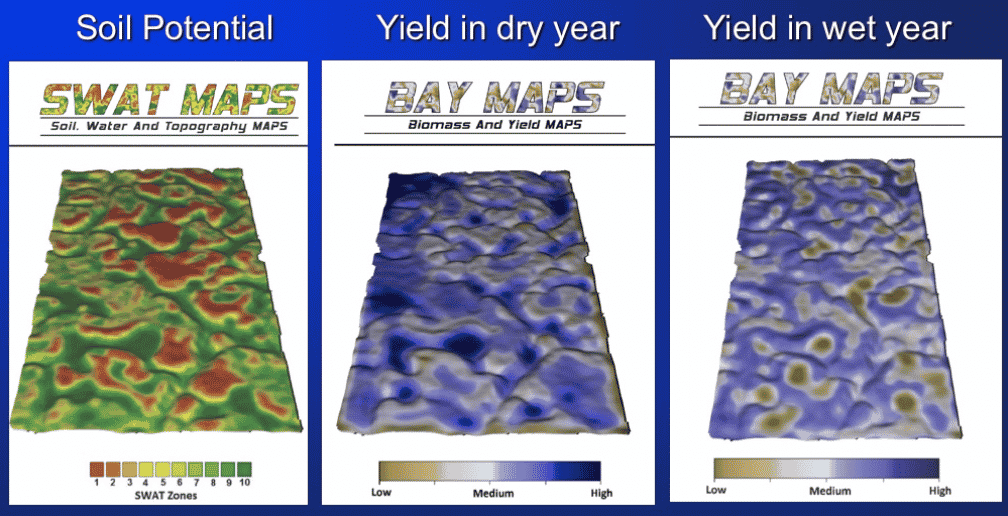
What is a FERTILITY ZONE? It is a combination of yield potential and soil potential. Yield potential maps are easy, quick and cheap to make but they are unstable and do not relate directly to fertility zones! Soil potential maps are hard, slow and more work to make but they provide a stable foundation to build soil sampling, water knowledge and ultimately a proper fertilizer response map when paired with yield potential.
Cory Willness, CCA, CAC, PAg
President - Croptimistic Technology Inc.
cory@croprecords.com
Become a SWAT News insider!
Sign Me Up!
Join Our Mailing List
Enter your email below to sign up for our mailing list.
We care about the protection of your data. We’ll never share your details.

Croptimistic Technology Inc. is an international agriculture technology (AgTech) company. We began operating in 2018. Croptimistic is supported by a growing team of professionals who have dedicated their careers to developing the best soil mapping software and hardware in the world.
Copyright Croptimistic Technology Inc. © 2024 All Rights Reserved.
Privacy Policy