0
$0.00 0 items

No products in the cart.

0
$0.00 0 items

No products in the cart.

From Field Mapping to Better Acre-by-Acre Decision Making

SWAT MAPS provides one system for understanding field variability from the ground up. Through high-resolution soil mapping, zone-based sampling, variable-rate prescriptions, and ongoing analytics, farmers can make more informed decisions about where to invest, where to adjust, and where to protect profit.
Book a Consultation
A Guided Process

FROM FIELD DATA TO DECISIONS, WITH EXPERT GUIDANCE ALONG THE WAY.

Getting started with SWAT MAPS does not mean adding another complicated tool to manage on your own. Your trained service provider handles the mapping, ground-truthing, sampling, prescriptions, and support needed to turn field variability into clear next steps.

You know your acres. They know the process. Together, you build a stronger foundation for every decision that follows.

Your role is simple: share your goals, provide available field information, and work with your provider to make decisions that fit your acres, equipment, and management strategy.
How it Works

A PROVEN PATH FROM FIELD VARIABILITY TO MANAGEMENT STRATEGY

Map the Field Foundation
Your field is mapped to collect high-resolution soil, water, and topography data, which is used to identify meaningful zones of variability.
Ground-Truth the Zones
Your service provider reviews the zones in the field to make sure it accurately reflects the visual soil and water patterns.
Soil Sample by Zone
Soil samples are collected by zone so nutrient levels, texture, soil carbon, and other properties can be understood in context.
BUILD VR PRESCRIPTIONS
Your provider creates prescriptions for any applications you need, based on SWAT zones, soil test results, field logistics, and equipment capabilities.
IN-SEASON MONITORING
Plant counts, tissue testing, crop observations, SWAT WATER, SWAT CAM, and other tools can help track what is happening in season.
ANALYZE & ADJUST
Soil analytics, yield analytics, and profit reporting help evaluate what worked and how each zone can be managed more effectively in future seasons.
The Foundation

THE TOOLS, TRAINING, AND SUPPORT BEHIND THE PROCESS

SWAT Records
Our desktop and mobile software that manages and integrates the entire SWAT ECOSYSTEM. It helps streamline the 12-step process and ensures accurate data management.
SWAT Support
Our knowledge base for farmers and partners. Here you can find frequently asked questions (FAQs), informative articles, and direct access to our support team for additional assistance.
SWAT Academy
Our online learning self-paced platform provides training for service providers. It teaches partners how to effectively execute each step of the 
SWAT ECOSYSTEM.
The Soil Potential Process

The Tech Behind Each Step

Everything starts in the soil. The soil potential process is based on creating high resolution soil foundation maps used to execute variable rate fertilizer, seed, soil amendment, pesticide, or precision water management. Understanding soils is the core of a successful fertility program. Every SWAT MAPS service provider will execute this 6-step process.
Step 1: SWAT BOX
The first step is collecting the quality data needed to create a SWAT MAP. A SWAT MAPS service provider will drive the field(s) in 80ft (24m) passes, using a SWAT BOX. The SWAT BOX is a patented autonomous soil mapping system that can be mounted to many different vehicles, most commonly trucks, ATVs or other off-road vehicles, but also seeders or planters.
Step 2: SWAT MAPS
The raw data collected by the SWAT BOX automatically gets uploaded and sent to our SWAT RECORDS software and is ready for our team of experts to analyze, it's then used to create multiple potential SWAT MAPS.
Step 3: Ground Truthing
With several potential SWAT MAPS created and uploaded to SWAT RECORDS, your service provider will return to the field(s) to ground-truth the maps and select the one that best represents your field. This one map becomes your permanent SWAT MAP to be used year after year. This is an essential step in the process, it ensures your SWAT MAP accurately depicts the soil and water variability in your field(s).
Step 4: Soil Sampling
Once the SWAT MAP is ground-truthed, it’s time to soil sample. Multiple cores are taken at 5 of the 10 SWAT zones, depending on field size, end goal, and the cost versus benefit of sampling intensity. The soil sample results will be uploaded to SWAT RECORDS when they are complete.

Soil samples are taken every year after harvest at geo-referenced locations to track nutrient levels and ensure your prescriptions are meeting your yield targets, accounting for soil mineralization and any nutrient losses.
Step 5: Soil Prescriptions
A SWAT MAPS service provider will work with their farmers to assess their operation. They have the local agronomic expertise to make informed recommendations through SWAT RECORDS with the support of our team.
Step 6: Soil Analytics
The last step in the soil potential process is to analyze nutrients, texture, and soil carbon data. Soil data can be connected to soil survey databases to assess varietal or hybrid crop responses to nutrients based on soil type.
Trusted by Farmers Globally

Proven Across Millions of Acres

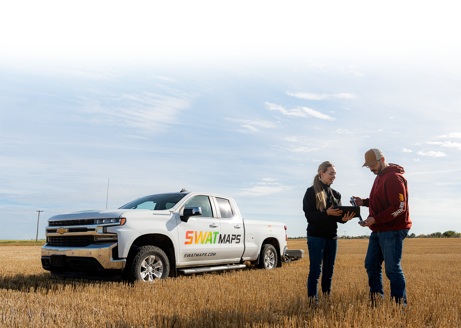
SWAT MAPS has achieved a 98% client acre retention rate year over year across millions of acres. Farmers continue using the system because it brings long-term value to their management decisions.

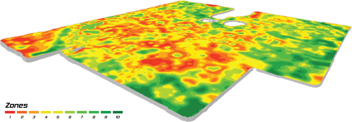
At the end of the process, you have:

  • A permanent SWAT MAP for each field
  • Ground-truthed zones based on soil, water, and topography
  • Zone-based soil sampling and analytics
  • Variable-rate prescriptions for key inputs
  • Field records and reports inside SWAT RECORDS
  • A foundation for future tools like SWAT WATER, SWAT CAM, Yield Analytics, and profit reporting
  • A clearer way to manage variability year after year

See if SWAT MAPS is the Right Fit for You

Have questions about SWAT MAPS and if they are a good fit for you? Book a discovery call with one of our team members who can provide answers to all your SWAT MAPS questions.
Book a Call Today!

See if SWAT MAPS is the Right Fit for You

Have questions about SWAT MAPS and how they work? Book a discovery call with an expert who can provide answers to all your SWAT MAPS inquiries.
Book a Consultation
Croptimistic Technology Inc. is an international agriculture technology (AgTech) company. We began operating in 2018. Croptimistic is supported by a growing team of professionals who have dedicated their careers to developing the best soil mapping software and hardware in the world.
Copyright Croptimistic Technology Inc. © 2026 All Rights Reserved