0
$0.00 0 items

No products in the cart.

0
$0.00 0 items

No products in the cart.

Know Where Your Farm is Losing Profit & Where to Gain it Back

SWAT MAPS helps farmers understand soil, water, crop establishment, and yield variability at a zone level, so you can make more confident decisions about where to invest, where to reduce costs, and where to push for higher returns.
The Hidden Cost of Unmanaged Variability

EVERY ACRE COSTS MONEY.
NOT EVERY ACRE RETURNS IT.

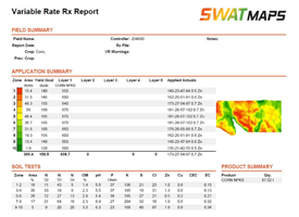
Every season, you’re making decisions about seed, fertilizer, crop protection, water, scouting, and harvest timing.

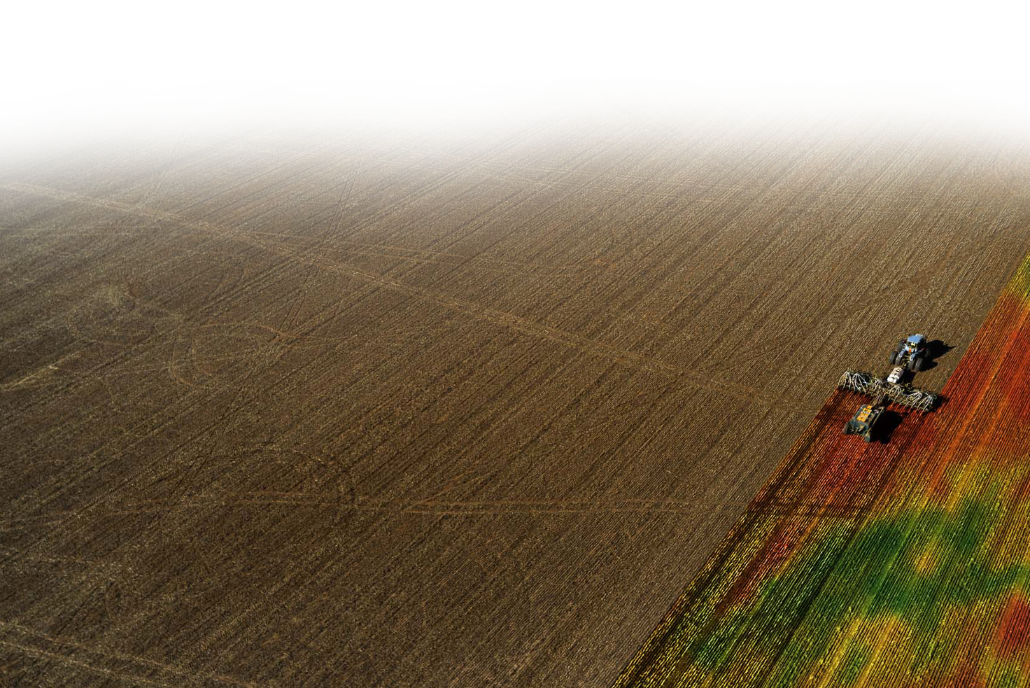
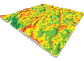
The challenge is that most fields have areas that consistently respond differently. Some zones have the potential to produce more with the right investment. Some zones may never return enough to justify the same input spend. And some zones need more investigation before you can make a confident call.

Without a clear understanding of field variability, it’s easy to over-apply in low-return areas, under-invest in high-potential areas, or rely on yield maps that only tell you what happened after the money has already been spent.
What You Get

How SWAT MAPS Helps You Manage Profit Zone By Zone

Understand Your Farm's Potential

Powered By  
SWAT MAPS creates high-resolution soil foundation maps that show how soil, water, and topography vary across your field. These zones become the base layer for variable-rate seed, fertilizer, soil amendments, pesticide decisions, and water management.

Instead of relying on broad averages, you can manage each zone based on its actual production potential.
DOWNLOAD SOIL POTENTIAL BROCHURE

Place Inputs Where They Have the Best Chance of Return

Powered By  
Once you understand your zones, you can make better decisions about where to increase seed and fertilizer, where to maintain, and where to cut back. SWAT MAPS helps you target inputs based on field variability, reducing unnecessary spend while supporting areas with higher yield potential.

Farmers using SWAT MAPS report a 6:1 ROI by making more precise input decisions across variable field conditions.

MONITOR WHAT IS HAPPENING DURING THE SEASON

Powered By  
  +  
SWAT WATER and SWAT CAM add in-season visibility to your SWAT zones. Soil moisture and rainfall observations help you better understand plant-available water and crop stress thresholds, while crop imagery provides zone-level insights into plant establishment, weed pressure, and seeding performance.

These tools help turn in-season variability into actionable decisions for herbicide, irrigation, and crop management.

On a 5,500-acre farm growing canola, wheat, and peas, improving seeding efficiency by 10% can save more than $32,000 in seed — about five times the first-year cost of SWAT CAM.
Learn More About SWAT CAM

Measure What Worked + Improve Next Year

Powered By  
Yield Analytics helps clean, calibrate, and compare yield data across seasons so you can see which zones consistently overperform or underperform. When paired with profit reporting by zone, you can compare expected yields against actual performance, calculate margins, and identify where returns are strongest or weakest.

This gives you a clearer way to refine future seed, fertilizer, and input decisions based on what actually happened in your fields.
Download Yield Analytics Brochure

What our Farmers are Saying About SWATMAPS

"With rising input costs, it's good to see where our dollars are going. Knowing the zones of our fields and being precise was important to us, and a spinoff of that would be the sustainability and the efficiency use of everything we're putting in. We're seeing salinity spots shrink, our crop maturity has been much more even, and it's allowed application and harvest timing to be much easier."
Brandon A., Premium SWAT MAPS Farmer

Connect with a SWAT MAPS EXPERT

Have questions about SWAT MAPS and how they work? Book a discovery call with an expert who can provide answers to all your SWAT MAPS inquiries.
Book a Call Today!

See if SWAT MAPS is the Right Fit for your Farm

Have questions about SWAT MAPS and how they work? Book a discovery call with an expert who can provide answers to all your SWAT MAPS inquiries.
Book a Consultation
Croptimistic Technology Inc. is an international agriculture technology (AgTech) company. We began operating in 2018. Croptimistic is supported by a growing team of professionals who have dedicated their careers to developing the best soil mapping software and hardware in the world.
Copyright Croptimistic Technology Inc. © 2026 All Rights Reserved