Unleash the power of the SWAT ECOSYSTEM.

Optimize crop performance, reduce input costs, and support sustainable farming through accurate, data-driven field zones.

How it Works

The SWAT ECOSYSTEM is a comprehensive 12-step process designed to enhance soil health and boost crop yields. It is divided into two main sections: the Soil Potential Process and the Yield Potential Process. It’s powered by three key components that form its foundation, ensuring that the entire process is interconnected and executed seamlessly.

SWAT RECORDS

Our desktop and mobile software that manages and integrates the entire SWAT ECOSYSTEM. It helps streamline the 12-step process and ensures accurate data management.
Learn more

SWAT SUPPORT

Our knowledge base for farmers and partners. Here you can find frequently asked questions (FAQs), informative articles, and direct access to our support team for additional assistance.
Learn more

SWAT ACADEMY

Our online learning self-paced platform provides training for service providers. It teaches partners how to effectively execute each step of the 
SWAT ECOSYSTEM.
Learn more
By following the steps in the SWAT ECOSYSTEM and utilizing these resources, SWAT MAPS service providers help their farmers unlock their full soil and yield potential, leading to more productive and sustainable farming practices.
The Soil Potential Process
Focuses on assessing and enhancing soil conditions
The Yield Potential Process
Aims to maximize crop yield based on soil health.

UNLOCK YOUR SOIL POTENTIAL

Everything starts in the soil. The soil potential process is based on creating high resolution soil foundation maps used to execute variable rate fertilizer, seed, soil amendment, pesticide, or precision water management. Understanding soils is the core of a successful fertility program. Every SWAT MAPS service provider will execute this 6-step process.
Step 1: SWAT BOX
The first step is collecting the quality data needed to create a SWAT MAP. A SWAT MAPS service provider will drive the field(s) in 80ft (24m) passes, using a SWAT BOX. The SWAT BOX is a patented autonomous soil mapping system that can be mounted to many different vehicles, most commonly trucks, ATVs or other off-road vehicles, but also seeders or planters.
Step 2: SWAT MAPS
The raw data collected by the SWAT BOX automatically gets uploaded and sent to our SWAT RECORDS software and is ready for our team of experts to analyze, its then used it to create multiple potential SWAT MAPS.
Step 3: Ground Truthing
With several potential SWAT MAPS created and uploaded to SWAT RECORDS, your service provider will return to the field(s) to ground-truth the maps and select the one that best represents your field. This one map becomes your permanent SWAT MAP to be used year after year. This is an essential step in the process, it ensures your SWAT MAP accurately depicts the soil and water variability in your field(s).
Step 4: Soil Sampling
Once the SWAT MAP is ground-truthed, it’s time to soil sample. Multiple cores are taken at 5 of the 10 SWAT zones, depending on field size, end goal, and the cost versus benefit of sampling intensity. The soil sample results will be uploaded to SWAT RECORDS when they are complete.

Soil samples are taken every year after harvest at geo-referenced locations to track nutrient levels and ensure your prescriptions are meeting your yield targets, accounting for soil mineralization and any nutrient losses.
Step 5: Soil Prescriptions
A SWAT MAPS service provider will work with their farmers to assess their operation. They have the local agronomic expertise to make informed recommendations through SWAT RECORDS with the support of our team.
Step 6: Soil Analytics
The last step in the soil potential process is to analyze nutrients, texture, and soil carbon data. Soil data can be connected to soil survey databases to assess varietal or hybrid crop responses to nutrients based on soil type.

Download the Soil Potential Brochure.

UNLOCK YOUR Yield POTENTIAL

The next stage in the SWAT MAPS process is the Yield Potential Process, it allows full-farm SWAT MAPS farmers take the next step in their precision agriculture journey. It provides premium in-crop services and industry-leading yield analytics.
Step 7: SWAT WATER
Using SWAT MAPS as the base layer, SWAT WATER takes detailed soil moisture sensor data, to create a soil water map. SWAT WATER calculates the field’s moisture holding capacity and plant available water. This information can be used for fertilizer top-dress applications, fungicides, growth regulators, and variable rate irrigation. To implement SWAT WATER, a weather station and soil moisture probe are required.
Step 8: SWAT CAM
SWAT CAM is an automated imaging system designed to capture, assess, and evaluate crop establishment and weed pressure. The SWAT CAM is mounted to a sprayer (one SWAT CAM on each boom) and captures images every 50 to 70 feet. These images are automatically uploaded to SWAT RECORDS where our software isolates the crop versus weed leaf area as well as plant stands for certain crops.
Step 9: Imagery
In season imagery can be helpful for monitoring all factors of your crops variability, not just soil and water. NDVI based maps are a great resource for writing VR on/off fungicide, crop desiccation, and plant growth regulator (PGR) prescriptions. When incorporated with the SWAT MAPS data layers, they can be used to enhance nitrogen topdressing prescriptions as well.
Step 10: Crop Prescriptions
Maximize your yield potential with real time crop variability and responses. Incorporated with SWAT MAPS data layers your SWAT MAPS service provider can write prescriptions for applications like on/off VR fungicide, plant growth regulators, top dressing, and crop desiccation. Farmers have access to unlimited in season prescriptions. This step is crucial for increasing yield and cost savings as well as using real time variability for treating relevant areas of the field(s).
Step 11: Yield Analysis
This is the heart and soul of the Yield Potential Process. With properly cleaned yield data, yield analytics allows SWAT MAPS service providers and their farmers to compare target vs. actual yields to adjust future targets to be more accurate, forecast profit and compare actual profit by crop and zone to identify zones with poor return and use this to adjust future strategies. Linking the yield to SWAT zones will help to understand yield trends by zone, by field, and spatial yield stability for better performance by zone and risk.
Step 12: SWAT Certified
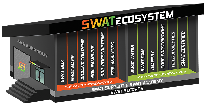
If farmers implement SWAT MAPS on their entire farm and follow the list of qualifications (available here), they’re eligible to be SWAT CERTIFIED, recognizing the commitment to environmental stewardship. An Advanced 4R Report is available to validate a farm practices.

SWAT MAPS service providers can become SWAT CERTIFIED by completing all the necessary training in SWAT ACADEMY.

Download the Yield Potential Brochure.

Potential Unlocked, Now what?

Unlocking your soil and yield potential is key to sustainable farming. Each season becomes a chance to refine your farming practices, enhancing yields and soil health year after year.

Service Providers

Harness the Power of the SWAT ECOSYSTEM.
  • Integrate a turn-key agronomy solution into your current business offerings
  • Become the local expert in precision agriculture
  • Increase your acreage retention rate
  • Manage your entire business with our suite of software and hardware tools
  • 24/7 access to our support portal and team of experts
Explore the Opportunity

Farmers

So Much More than a Map.
  • Optimize your inputs and manage field variability
  • Experience more even crop staging and maturity along with improved standability
  • Boost your return on investment (ROI) by only applying nutrients where they are needed
  • Generate short- and long-term benefits to farm productivity, profitability, and sustainability
Unlock Your Potential
Croptimistic Technology Inc. is an international agriculture technology (AgTech) company. We began operating in 2018. Croptimistic is supported by a growing team of professionals who have dedicated their careers to developing the best soil mapping software and hardware in the world.
Copyright Croptimistic Technology Inc. © 2025 All Rights Reserved