Partner with SWAT MAPS.

Enhance your services and set yourself apart by harnessing the only all-in-one soil mapping solution on the market. Deliver tailored recommendations that maximize yields and optimize inputs. 

Unlock the Benefits of the SWAT Ecosystem

SWAT MAPS is a scalable business developing premium precision ag products and services, delivered to farmers by independent service providers. Our franchise-style partnership opportunity pairs your agronomy expertise with our industry leading technology and brand to take your business to the next level. Below are three reasons you should become a SWAT MAPS partner today.
Get a Free SWAT MAPS Demo

The Only All-In-One Solution

We’re proud to provide the only all-in-one variable rate service on the market. From data collection to yield analytics, we’ve perfected the process so you can focus on supporting your farmers and growing your business.

A Turnkey Solution

Say yes, and we’ll handle the rest! Our onboarding process ensures you have everything needed for success, with one-on-one support covering marketing, sales, and more, every step of the way.

Free Access to SWAT Academy

Your team gets free access to SWAT ACADEMY, featuring step-by-step training videos for the entire SWAT MAPS process. Learn at your own pace, whenever it works for you.

24/7 Access to SWAT SUPPORT

The SWAT SUPPORT portal offers FAQs, cheat sheets, and live chat with our team. Plus, enjoy exclusive content like marketing tools and a community forum for advice from fellow service providers.

Build a Million Dollar Business

Watch our “Building a Million Dollar Business” video in SWAT ACADEMY to learn how other service providers achieved success—and how you can too!

Easy-To-Use Soil Mapping System

The patented SWAT BOX is ready to go out of the box. Mount it to your vehicle, connect to SWAT RECORDS, set up RTK (or use LiDAR), and start mapping—no sleds, mud, or multiple passes required! We clean the data, and you get to focus on agronomy!

Run Your Business with SWAT RECORDS

SWAT RECORDS connects all our products and services in one platform. Everything you need to run your agronomy business is right at your fingertips, and it all data syncs to your farm client users.

Backed by the SWAT MAPS Brand

By adding SWAT MAPS to your business, you have the support of a well-established brand behind you. This gives you instant credibility with farmers, along with access to proven business models and marketing tools to help you succeed from day one.

Sustainability

SWAT MAPS promotes responsible input use, supporting environmentally friendly farming practices while maintaining productivity.
These benefits are unlocked through the Soil Potential Process. By precisely understanding soil properties and conditions, farmers can optimize inputs, enhance crop health, and achieve higher yields with targeted strategies. The Soil Potential Process lays the foundation for sustainable, productive farming that maximizes every acre’s potential.
 

Download the Partner Details

What SWAT MAPS Users Are Saying

Join SWAT MAPS Partners around the World

Partner with SWAT MAPS and join likeminded agronomy experts offering a premium precision agriculture service to their farmers. As a partner, you'll gain access to cutting-edge tools in the SWAT ECOSYSTEM, and impactful projects that drive positive change worldwide. Be part of the movement—together, we can create solutions that make a difference.
Chat with SWAT MAPS Expert

SWAT MAPS 
Service Providers

We partner with service providers to bring SWAT MAPS to farmers around the globe.
Find a Service Provider

Explore the SWAT Ecosystem Tools

Jump start your agronomy business and partner with SWAT MAPS to join likeminded agronomy experts offering a premium precision agriculture service to their farmers. As a partner, you'll gain access to cutting-edge tools in the SWAT ECOSYSTEM and impactful projects that drive positive change worldwide. Be part of the movement—together, we can create solutions that make a difference.
Chat with SWAT MAPS Expert
The patented SWAT BOX is an autonomous soil mapping hardware system that collects the data needed to create our patented SWAT MAPS. It’s the first step in the SWAT ECOSYSTEM and is essential to our process.
The SWAT CAM is mounted to a sprayer (one SWAT CAM on each boom) and captures images every 50 to70 feet. These images are automatically uploaded to SWAT RECORDS where our software separately assesses the crop versus weed leaf area. From this assessment, you’ll receive an auto-generated ‘Crop and Weed Map’ summarizing your crop and weed data by SWAT zone.

Your farmers can download and use the app for free. The desktop software includes everything needed to run your SWAT MAPS business. Key features include:

Access All Your SWAT MAPS and Files in One Place
View the SWAT MAPS for each of your fields. The maps can be viewed in the app and are georeferenced for ease of use when scouting.

View all the fields you manage on one screen.
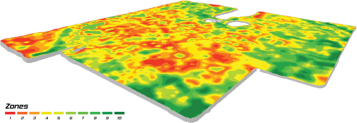
Colour code your field outlines by crop. Navigate easily for scouting and sampling.

Field Scouting and Recommendations
Input your field scouting data for weeds, insects, and diseases and view recommendations for your farmers to view directly in the app.

Create and Reference Soil Sample Locations
Create and take soil samples are from the same geo-referenced location every year. This gives you the ability to track nutrient levels and ensure prescriptions are meeting your farmers yield targets, accounting for soil mineralization and any nutrient losses.

Create Jobs and Recommendations for Your Farmers
Your farmers can view recommendations in the app and make them as complete when finished.

View Soil Sample & Tissue Test Results
Soil sample and tissue test results can be directly imported to SWAT RECORDS by your lab or you can input them manually for your farmers to view. SWAT RECORDS connects with many labs globally, with more labs added regularly.

Rural Connectivity
The app works without a cellular or wi-fi signal; any changes made are saved in the app and synchronized when connection is re-established.

Data Policy
We take your data seriously and are committed to protecting your privacy. Your farmers will always own their data.

Connections
Share your SWAT MAPS, SWAT WATER maps, flow paths and more with the following apps. More connections being added regularly!

Connected apps: Agvise Laboratories, Climate Fieldview, GK Technology for Agriculture, Metos Pessl, John Deere.

The SWAT RTK boasts 75% lower entry costs, fast installation, and seamless integration with SWAT BOX. Enjoy advanced features, direct support, and a one-year parts warranty for a reliable, cost-effective solution.
The patented SWAT BOX is an autonomous soil mapping hardware system that collects the data needed to create our patented SWAT MAPS. It’s the first step in the SWAT ECOSYSTEM and is essential to our process.
Using SWAT MAPS as the base layer, SWAT WATER takes detailed soil moisture sensor data to create a soil water map. SWAT WATER calculates your field’s moisture holding capacity, plant available water, and days to stress by zone. This information can be used for fertilizer top-dress applications, fungicides, growth regulators, and variable rate irrigation.

To implement SWAT WATER on any farm, a weather station and soil moisture probe are required.
SWAT MAPS are essential for precise fertilizer and seed applications, providing insights into field variability. Understand and manage your fields better to enhance crop inputs and maximize profitability.

Connect with a SWAT MAPS EXPERT

Have questions about SWAT MAPS and how they work? Book a discovery call with an expert who can provide answers to all your SWAT MAPS inquiries.
Book a Call Today!
Croptimistic Technology Inc. is an international agriculture technology (AgTech) company. We began operating in 2018. Croptimistic is supported by a growing team of professionals who have dedicated their careers to developing the best soil mapping software and hardware in the world.
Copyright Croptimistic Technology Inc. © 2025 All Rights Reserved